
Port Adelaide, SA (499.2km)
Verified
Also available:
Land Surveyors
Cadastral Surveyors
Engineering Surveyors
Also available:
Land Surveyors
Cadastral Surveyors
Engineering Surveyors

Gofer is an AI sourcing tool powered by iseekplant.
Tell Gofer what you need and it will help you create a job request and connect you with relevant local suppliers.

Also available:
Hydromulching
Hydroseeding
Revegetation

Also available:
Land Surveyors
Mining Surveyors
Surveyors
Also available:
Engineering Surveyors
Mining Surveyors
Cadastral Surveyors

Also available:
Engineering Surveyors
Cadastral Surveyors
Land Surveyors
Also available:
Land Surveyors
Mining Surveyors
Engineering Surveyors

Also available:
UAV and Drone
Camera Inspections
Drain Camera Inspection

Also available:
D8 or Equivalent Caterpillar Tracked Dozer
Powerscreen Screening Plant
Slasher
Also available:
Surveyors
UAV and Drone
GPS Machine Control Systems

Also available:
Surveyors
Land Surveyors
Engineering Surveyors

What we have learned from MYOB’s 2022 Bold Ambition report Talk to ...
Have you ever wondered how large structures or long distances are measur...
iseekplant, the largest online construction hire marketplace in Australia, continues to deliver the best aerial surveying services by providing aerial surveyors in Roxby Downs. Our vast online services enable Roxby Downs residents to find the best aerial surveying contractors in their area. iseekplant provides contact details that allow you to directly connect with different aerial surveying companies in Roxby Downs for an easy and convenient quote. Take a look at our listing below.
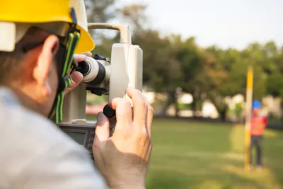
An aerial surveyor uses aerial photography or remote-sensing imagery to analyse a property from the air. Traditionally, aerial surveying is normally performed by using manned aeroplanes where sensors are set up to calibrate data. Nowadays, aerial surveyors uses different tools and technologies to collect information. These tools include aerial photography, radar, laser or even remote sensing imagery that uses different bands of the electromagnetic spectrum, such as ultraviolet, gamma, and infrared.
Once the data is collected, the aerial surveyor will then process the data to create high-resolution orthographic images, 3D digital models of the terrain, and point clouds. This depends on the type of sensor used. Different sensors are used to collect different types of information.
Aerial surveying services are typically completed in large areas where it can provide information on many things not visible from the ground. This method also eases the time spent in taking numerous site visits, making it more efficient.
Another use for aerial surveying services includes having complete large detail survey for construction, transport and infrastructure. This can also be utilised in the monitoring of construction as well as site development. Aerial surveying contractors also use this method to indicate volumetric calculations for bulk earthworks, stockpiles and landfills.
In some cases, aerial surveying is performed for disaster and environmental monitoring.
Aerial surveying is a complex process that requires professional assessment. While there are many aerial surveying companies to choose from, it’s still recommended to hire the best contractor for this type of job. iseekplant provides the best aerial surveying contractors in Australia, try looking at our aerial surveyors in Roxby Downs list and find the best contractors near you.
iseekplant provides the listings of trusted and expert aerial surveyors in Roxby Downs. We’ve assisted projects nationwide by supplying qualified surveyors. If you can’t find any in your location, try viewing our aerial surveyors in Olympic Dam, Woomera, Port Augusta, Iron Knob or Coober Pedy. Here are a number of related services we think you might be interested in, such as Land Surveyors, Mining Surveyors and Building Surveyors.